Satellite Images Reveal Massive Crater from Devastating Iran Port Blast
Recent satellite imagery has unveiled the devastating aftermath of the April 26 explosion at Iran’s Rajaei port. The explosion, which resulted in the tragic loss of at least 70 lives, left behind a significant crater, as evidenced by photos acquired by Iran International. This incident has raised concerns regarding safety protocols in port operations and the potential implications for maritime activities in the region.
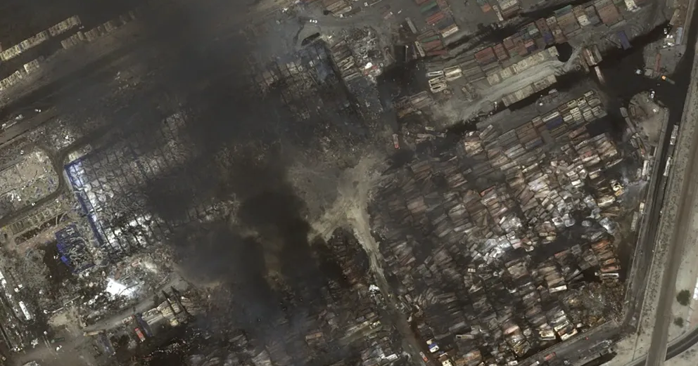
According to the satellite images captured on April 30, a massive crater has formed directly in front of the administrative building of the Sina Marine and Port Services Development Company, which was identified as the epicenter of the explosion. The scale of destruction is profound, as the images depict:
- Complete destruction of the Sina Company’s administrative building, located in the northwest section of the compound.
- Severe damage to adjacent warehouses and at least three other structures.
- Extensive burning of trees in the surrounding area.
The satellite imagery clearly illustrates the extent of the destruction, with numerous shipping containers crushed on both sides of the explosion site. This highlights the catastrophic impact of the explosion on port operations.
As previously reported by Iran International, the Sina yard, spanning 15 hectares and capable of housing between 12,000 to 20,000 twenty-foot containers, has been entirely obliterated. The latest satellite photographs corroborate this alarming report, showcasing the complete devastation that has occurred.
In addition to the destruction at the Sina yard, the new images reveal the total annihilation of a large administrative building located in the nearby Onik yard, situated to the north of the Sina area. This damage had not been reported earlier and underscores the broader implications of the incident.
Moreover, the Khazar Qeshm Company, which occupies a yard of 10 hectares to the west of the Sina yard, has also suffered extensive damage. The satellite images indicate that the roof of the company’s warehouse, located approximately 500 meters from the explosion’s epicenter, has been completely torn apart.
To summarize the key details regarding the explosion and its aftermath:
- The explosion occurred on April 26, resulting in at least 70 fatalities.
- Satellite images reveal a large crater at the Sina Marine and Port Services Development Company.
- The administrative building of Sina has been completely destroyed.
- Adjacent structures and warehouses experienced severe damage.
- The surrounding trees are visibly burned, indicating the explosion’s intensity.
- The Sina yard, capable of accommodating thousands of shipping containers, has been entirely destroyed.
- The Onik yard’s administrative building was also found to be completely destroyed.
- Khazar Qeshm Company’s warehouse roof has been torn apart due to the explosion.
The implications of this explosion extend beyond the immediate loss of life and property. The destruction of critical infrastructure at Rajaei port raises questions about the safety measures in place for port operations and the potential repercussions for shipping activities in the region.
As investigations continue into the causes of the explosion, there is a pressing need for enhanced safety protocols to prevent such tragedies in the future. The port serves as a critical hub for maritime trade, and the loss of such facilities could have far-reaching economic consequences.
In conclusion, the recent satellite images of the Rajaei port explosion present a stark reminder of the potential dangers associated with port operations. With the extent of the destruction now documented, it is crucial for authorities to address safety concerns and implement measures to safeguard against future incidents.


