Over 100 Earthquakes Rattle Iran in Just One Week: What You Need to Know
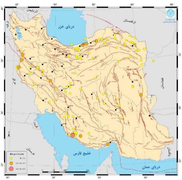
In the 4th week of Bahman, which spans from February 8 to 14, a significant total of 105 earthquakes were recorded throughout Iran, according to the seismological networks operated by the Institute of Geophysics at the University of Tehran. This surge in seismic activity highlights the country’s ongoing challenges with earthquakes and natural disasters.
Statistical data reveals that:
- 92 earthquakes had magnitudes less than 3
- 12 earthquakes registered between 3 and 4
- 1 earthquake reached a magnitude of 4 to 5
Notably, the earthquake with a magnitude of 4 occurred on February 10, with its epicenter located in Kangavar, a city in the western Kermanshah province. This incident underscores the seismic volatility of the region.
Among the provinces, Khorasan Razavi reported the highest frequency of earthquakes, totaling 17, followed closely by:
- Fars and Bushehr: 10 earthquakes each
- Kermanshah: 9 earthquakes
Interestingly, no seismic events were recorded in several provinces during this period, including:
- East Azarbaijan
- West Azarbaijan
- Ardabil
- Alborz
- Kohgiluyeh-Boyerahmad
- Markazi
- Qom
- Gilan
- Qazvin
- Zanjan
Throughout the past calendar year (March 2023 – March 2024), a total of 6,949 earthquakes were documented across Iran. The distribution of these seismic events was notable, with the majority occurring in:
- North-eastern Khorasan Razavi
- South-eastern Kerman
- North-western West Azarbaijan
- Eastern South Khorasan
The seismic statistics indicate:
- 2,268 earthquakes measured less than 2 on the Richter scale
- 3,685 earthquakes fell between 2 and 3
- 796 earthquakes were between 3 and 4
- 181 earthquakes ranged from 4 to 5
- 22 earthquakes were between 5 and 6
- 5 earthquakes reached between 6 and 7
The Iranian plateau is situated in one of the most seismically active regions globally, notorious not only for its frequent catastrophic earthquakes but also for various natural hazards. It is noteworthy that while Iran experiences approximately 2 percent of the world’s earthquakes, over 6 percent of the global earthquake-related fatalities in the 20th century occurred within its borders. This statistic illustrates the high level of vulnerability in Iran, as highlighted by Mehdi Zare, a professor of engineering seismology.
According to Professor Zare, Iran has entered a decade marked by heightened seismic activity since the Iranian calendar year 1396 (March 2017 – March 2018). The shrinking of the Iranian plateau, estimated at 30 millimeters per year, contributes to this ongoing seismic threat.
The Strait of Hormuz area in southern Iran is recognized for its intense seismic activity, which results from the ongoing convergent movement between the Arabian plate and the central continental plate of Iran. This particular geological dynamic significantly impacts the region’s earthquake patterns.
Tehran, the capital city, is particularly vulnerable, being one of the most disaster-prone metropolises worldwide. The city faces risks from various natural disasters, including:
- Earthquakes
- Floods
- Subsidence
- Drought
- Landslides
- Fire following an earthquake
With a night-time population exceeding 8.3 million, Tehran is characterized by a mix of aging non-resistant structures and modern high-rise buildings, both contributing to its overall vulnerability to seismic events. As the frequency of earthquakes continues to rise, understanding and mitigating these risks is crucial for the safety of the population.


