Exploring Timeless Journeys: Unveiling ‘The Book of Routes and Realms’
The Book of Routes and Realms (Kitāb al-Masālik wa al-Mamālik), authored by Ibrāhīm al-Iṣṭakhrī, stands as a monumental achievement in the field of geography. Written in the 4th century AH (10th century CE) in Arabic, this influential work meticulously outlines the regions of the Islamic world, categorizing them into twenty distinct areas based on their size and significance.
Abū Isḥāq Ibrāhīm ibn Muḥammad al-Fārisī al-Iṣṭakhrī, frequently referred to as al-Karkhī, was a preeminent geographer of his time and hailed from Istakhr (modern-day Persepolis) in the Fars province. His contributions are widely recognized as foundational to the development of geographical studies within the Islamic context.
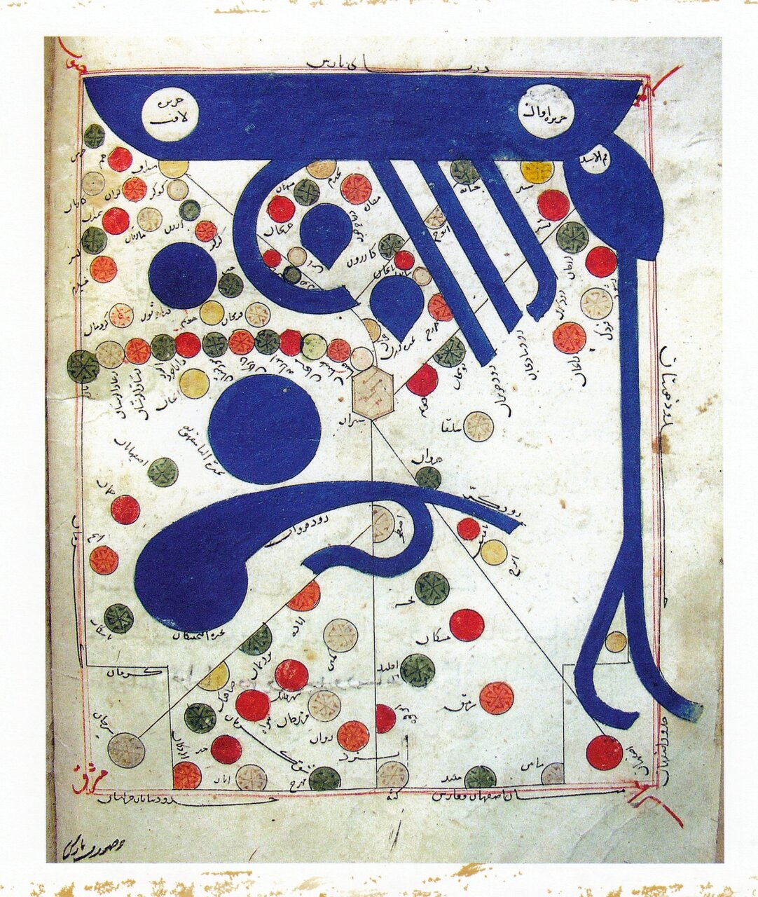
The manuscript of the Book of Routes and Realms, currently housed at the National Museum of Iran, is one of the oldest surviving texts from the Seljuk period and represents the most comprehensive translated version of Kitāb al-Masālik wa al-Mamālik. This pivotal work was likely translated into Persian under the same title (Masālik va Mamālik) during the 5th or 6th century AH. Later, in 726 AH, a significant transcription was performed by Abū al-Maḥāsin Muḥammad ibn Saʿd ibn Muḥammad al-Nakhjawānī, also known as Ibn Sāwjī, in Isfahan. This transcription was executed on government-issued paper (kāghaz-e Dowlatābādī) and extends over 275 pages.
This manuscript is not only significant for its content but also for its artistic presentation. It features:
- 13 gilded and ornamented headpieces
- 20 colored maps
- 2 black-and-white maps
The binding of the manuscript is crafted from cardboard and covered with tīmāj leather, complete with a flap. The front cover showcases a gilded embossed tarang (medallion) design, adding to its aesthetic appeal.
The Persian translation of Masālik va Mamālik is preserved at the National Museum of Iran, specifically within the Museum of Islamic Archaeology and Art, identified by inventory number 3515. This remarkable work is esteemed not only for its scholarly content but also for its profound impact on Persian prose and the quality of its hand-drawn colored maps. Because of its cultural and historical significance, it was registered under No. 1005 in the UNESCO Memory of the World Committee’s national list in 2008 CE (1387 SH), following a recommendation from the Islamic Republic of Iran.
In the pages of Masālik va Mamālik, al-Iṣṭakhrī offers an extensive exploration of various countries and regions. His descriptions encompass:
- Distances and boundaries
- Valuable commercial products and industries
- The conditions of different peoples
- Historical monuments, including fortresses and fire temples
The most comprehensive section of this illustrious book is dedicated to the land of Persia (modern Iran). Notably, the map of the Persian Gulf is labeled “Ṣūrat Baḥr Fārs” (Image of the Persian Sea), while the map of Iran is identified as “Ṣūrat Bārs” (Image of Persia). In this context, the term “ṣūra” (image) is utilized to denote a map, highlighting the geographical precision of al-Iṣṭakhrī’s work.
Through his meticulous observations and detailed accounts, Ibrāhīm al-Iṣṭakhrī has left an indelible mark on the field of geography. His work not only serves as an essential resource for scholars and historians but also enriches our understanding of the Islamic world during the 10th century. The Book of Routes and Realms continues to be a vital reference point for those exploring the history and geography of this influential era.
